
Neighbourhood Studies
No. 2 - St Cross & its Surroundings
8 Conservation Area
The Winchester conservation area was designated in 1967, and since then the motorway has been completed. This has opened the door to pressure for commercial development on greenfield sites near motorway junctions, such as Bar End and Compton. Another change has been railway electrification, which has brought Winchester from the edge to well within the London commuter belt. These improvements in access to London have increased the pressure for residential development in the district. The motorway and its junctions are built to a scale much larger than Winchester's street infrastructure and its radiating Roman roads, or the railway.
A case can be made for extending the conservation area to include undeveloped spaces to the west of the motorway. The land between the River Itchen and the canal is a valuable open space but, being former water meadow, is wetland and largely inaccessible to the public; there are however pleasant views across it, and it is a tranquil place to be near. When walking along Five Bridges Road the drop in noise level from the motorway after passing through a break in the railway embankment is very noticeable. If the viaduct were removed, given a south wind, the noise impact on St Cross Village might be considerable. This issue makes a very strong case for an extension of the conservation area to control conditions in the one already existing. The viaduct is an example of an early reinforced-concrete structure encased in brickwork. The early (1710) Itchen Navigation still exists to the first lock, below which the bed has recently been drained leaving it dry. The straight section by Palmer Field is impressive when viewed from St Catherine's Hill.
St Catherine's Hill
This is a recreational area of long standing, and the top of the hill is a very worthwhile objective for both the tourist and resident walker, giving a sense of fulfilment when it is reached. Its historical interest lies in the iron-age fort, the visible remains of which are the rings of ditch fortifications and the old turf maze. The site of the mediaeval St Catherine's Chapel is no longer visible. On the south side of the hill is Plague Pits Valley, where victims of the 1666 plague were buried.
As one walks round the top of the hill there is a succession of fine views, the Hospital of St Cross and the Cathedral being in the first rank. These views are of breath-taking quality, giving the opportunity to appreciate these buildings in some detail from an unusual angle. It is a particularly good place to appreciate the jewel of St Cross Church from a viewpoint that changes as one walks along. There is also a panoramic view of the city that includes the tree-covered slopes of Sleepers Hill and West Hill, the Royal Hampshire County Hospital, the prison watch tower, the intrusive Police Headquarters and the spire of St Thomas's Church. From this vantage point it can be appreciated that the Cathedral is still the most dominant building in the city; and on a clear day the Isle of Wight may be seen to the south.
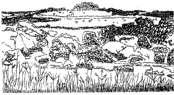
St Catherine's Hill from the North Field, Bushfield Camp
St Catherine's Hill is in the East Hampshire Area of Outstanding Natural Beauty (AONB). It has now been severed from the rest of the AONB by the M3. The closure, removal and landscaping of the by-pass site has achieved a reunification of the hill with Winchester, and it would now seem logical that the hill should be included in the Winchester conservation area, for it is a part of Winchester's history and is a landmark to be seen from many places in and around the city. It belongs to Winchester College and is leased to the Hampshire & Isle of Wight Wildlife Trust, who wish to maintain it as chalk downland to encourage a flora and fauna typical of this habitat. This policy requires that the scrub (thorns, brambles, hazel etc) should be removed to prevent the enrichment of the soil, with a further requirement to keep the grass short by grazing Sheep and cattle are grazed here, so the Warden has to pursue a policy of educating the public into keeping their dogs under control.
The Beech clump gives the hill its special significance as a landmark and it is regrettable that the trees appear to be in poor condition. Until recently the maze has been maintained by a volunteer group who knew how to repair the raised turf strips maintained the maze turf. Sadly, since then these are breaking up as a result of people walking straight across the maze. The dugout paths are now overgrown with grass in parts.
Bushfield Camp
To the west of the Hospital and the railway lies a triangular piece of land consisting of the former army camp at Bushfield and its three attendant fields to the west, south, and north, of which the last two fields and the camp should be included in the conservation area. This control is necessary to preserve the incomparable setting of St Cross as seen from St Catherine's Hill, although this may not be sufficient because of the long-term pressure from the Church Commissioners, owners of much of the land, for a large residential development on the site. The main objection to building on the north and south fields is that it would disturb the green and gold backcloth to the view of the Hospital from St Catherine's Hill by replacing it with distracting buildings which would seriously damage a scene that has changed little since Norman times. The very satisfying composition of the Church is particularly vulnerable to competition from any new buildings to its west. The long abandoned army camp site, which has given its name to the area, is being considered by the City Council for development as a sports and hotel complex. Although this would be partially shielded by trees and the lie of the land, there are grave worries about the impact the roofs and floodlighting would have on the local environment. Whether coupled with these proposals or as an independent development, the prospect of a major Park-and-Ride on this site raises similar concerns.
The north field could be utilised as an informal recreational and possible grazing area, with the benefit of certain views of the Hospital, the College chapel tower, the Cathedral and the beautiful range of hills to the east. These buildings are enhanced by the whitish grey colour of their finish and by their neighbours being hidden by the trees. With the sun in the west and maybe dark clouds to the north, the buildings have a remarkably luminous quality, a dramatic effect that can be marvellous under almost any weather conditions. Scrub clearance in the foreground will be important to ensure the future of this view; because of the low angle of view resulting from existing trees in the College grounds where their growth could become a hindrance.
As a viewing point the north field is second only to St Catherine's Hill and, if preserved, might compensate to some extent for the steady erosion of amenity land in North Walls Park at the other side of the city; it is certainly more picturesque than North Walls because it is free of buildings, cars and other paraphernalia. If any development or amenity improvement is envisaged at Bushfield, it is critical that its existing characteristics should be preserved as much as possible. The conservation of the field may need some improvement, but it is essential that its sense of naturalness should be retained.