
Neighbourhood Series
No. 2 - St Cross & its Surroundings
INDEX
This neighbourhood study is one of a short series, focusing on individual areas of Winchester. It is not intended to be a definitive guide to the area, but it is hoped that it will provide some useful background information concerning the history and character of the various parts of the city that make up the whole. The word "area" will be used to mean "neighbourhood" throughout the rest of the study. The picture is always changing, so we may produce updated versions in due course. Readers who have suggestions for amendments or additions are therefore welcome to write to the Trust so that their comments can be filed for future reference.
Contents
November 2003
Prepared by Nick Bourne, DipArch
For the City of Winchester Trust
With many thanks for the invaluable help given by Andrew Rutter
Map produced by kind permission of Ordance Survey
© crowncopyright NC/99/322
The City of Winchester Trust is supported by Hampshire County Council
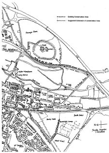
Map of St Cross (click to enlarge)