
Winchester St. Thomas Street
Introduction
St. Thomas Street runs north and south from High Street to St. Swithun's Street, that being the city boundary in Roman times. It has always been favoured as a residential area with small cottages and large houses having suitably extensive gardens. The 19th century Ordnance Survey maps indicate the sites of Roman pavements, and present day excavations at the S.W. corner show masonry walls of a Roman town house with a tessellated pavement.
Speed's map of 1611 shows the north end of the street with tenements and cottages and gardens on the west side as far as St. Thomas's Passage. This area of the town was considered a healthier district than the low lying Brooks. Under the Paving and Street Lighting Act of the 1770s the road from the High Street to St. Clement Street was paved and partly paid for by adjoining owners. There was private piped water by the Winchester Water Supply Co. in the 1850s but no main drainage until after 1878.
At this part of the street was a brewery and nearby the King's Head Inn, mid 17th century and demolished in 1936. The public right of way across the site remained and the name retained when development took place in the early 1980s. These changes were part of a developer-architect competition organised by Winchester City Council for the improvement of property in Little Minster Street. The winning scheme by Plincke Leaman and Browning, architects, included two corner shops in addition to town houses and offices.
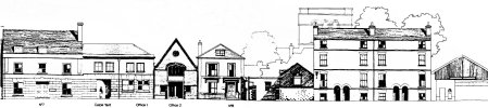
(Note : Below is a thumbnail of of an architectural drawing of the façade of part of the street. Click on the thumbnail for a larger version of the façade.)
panoramic view click to enlarge