
Winchester Timeline 1957-2017 - TrustNews July 17
Winchester Timeline 1957 - 2017
| CITY GUIDE: | c.Iate 1950 s Guide to Winchester1956-7 |
| CITY AREA : | administrative area 3.888 acres (1573 ha) |
| built up area 865 ha approx. | |
| CITY OFFICE: | Main Departments, Guildhall. Telephone 3361 |
| Housing Department, The Square. Telephone 3361 | |
| Health Department, The Square. Telephone 3347 | |
| EARLY CLOSING DAY: | Thursday |
| MARKET DAY: | Monday |
| POPULATION : | 27, 150 (density 31 persons per ha. approx) |
| POST OFFICE: | Parchment Street |
| 1956-7 | St. George's Street widened |
| 1956-7 | Demolition of parts of Lower and Middle Brooks Streets and surface car park built. |
| 1958 | Cottages demolished in North Walls for building of new police station |
| 1959 | Road around Westgate built |
| 1959 | Barclays Bank built on the site of the George Hotel |
| 1959 | Demolition of gasometer in Andover Road |
| 1959-60 | County Council Offices - Queen Elizabeth Court - built |
| 1961 | Chesil Railway Station closed to passengers (line closed 1965) |
| 1962-4 | Buildings in Colebrook Street demolished and replaced by Wessex Hotel |
| 1962 | Construction of shops and offices in St. George's Street, designed by Sir Hugh Casson |
| 1963 | Lion Brewery, latterly Co-op Bakery, Eastgate Street demolished |
| 1963 | First multi-storey flats built at Winnall |
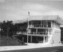
| 1966 | New Police Headquarters built in Romsey Road |
| 1966 | Winchester Art College moved to Park Avenue |
| 1966 | New Post Office opened in Middle Brook Street |
| 1967 | London to Southampton railway line electrified |
| 1968 | Three quarter Ring Road proposal promoted |
| 1969 | King's Worthy Link Road opened, removing A34 traffic through Winchester |
| 1972 | Post of City Archaeologist created |
| 1974 | Local Government reorganisation - new Winchester District Council formed with new offices in Colebrook Street |
| 1974 | Peter Symonds changed from a boys grammar school to a sixth form college |
| 1974 | High Street pedestrianised |
| 1974 | Law Courts opened by the High Chancellor, Lord Hailsham |
| 1974 | Badger Farm Road opened |
| 1978 | Pedestrian underpass built in Sussex Street |
| 1979 | 900th anniversary of Winchester Cathedral |
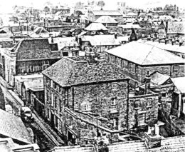
1950s - Brooks Area
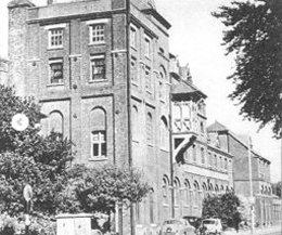
1960s - Co-op Bakery Eastgate St
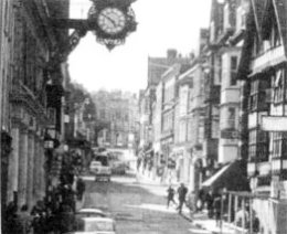
1970s - Pre-pedestrian High Street
| 1981 | Exhibition of sculpture by Elizabeth Frink held outside Great Hall |
| 1985 | Army left Peninsula Barracks for new depot at Flowerdown |
| 1985 | Parish of Badger Farm formed |
| 1985 | Avenue of limes leading to west front of the Cathedral felled |
| 1986 | New Sainsbury supermarket at Badger Farm |
| 1985-6 | Chesil Street multi-storey car park built |
| 1986 | Royal Hampshire County Hospital extended with Nightingale Wing |
| 1988 | River Park Leisure Centre opened |
| 1988 | West Downs School, Romsey Road closed |
| 1989 | Cattle Market in Andover Road closed - in operation since 1588 |
| 1989 | Odeon cinema in North Walls closed |
| 1990 | Army Museums opened |
| 1991 | Brooks Shopping Centre opened |
| 1991 | Hampshire Chronicle office in High Street closed |
| 1993 | Hampshire Record Office opened on site of Carfax Hotel |
| 1993 | Cathedral Visitor's Centre opened |
| 1994 | M3 extension through Twyford Down opened |
| 1994 | Tour de France came through Winchester |
| 1999 | Whitwam music shop in High Street closed |
1950s - Brooks Area
1990s - Hampshire Record Offices
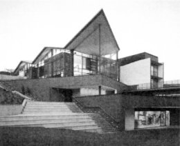
2000s - University of Winchester
| 2001 | Theatre Royal, Jewry Street restored |
| 2005 | Privy Council conferred the title of the University of Winchester |
| 2006 | Cathedral, first ice rink and Christmas market |
| 2008 | Winchester Discovery Centre opened |
| 2009 | Pedestrian area of High Street repaved |
| 2009 | The Kite Flyer sculpture installed in Parchment Street |
| 2010 | South Winchester Park and Ride opened |
| 2010 | South Downs National Park Authority established |
| 2016 | Housing at Barton Farm started |
| 2016 | Police Station in North Walls demolished |
| 2016 | Construction of Extra Care homes in Chesil Street |
| 2017 | County Police Headquarters in Romsey Road demolished |
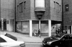
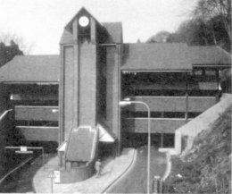
2010s - County Police Headquarters
| CITY GUIDE: | 2017 current Visitor's Guide |
| CITY AREA : | built up area 1171 ha approx in 2011 |
| CITY OFFICE: | City Offices, Colebrook Street SO23 9LJ |
| 01962 840 222 | |
| SHOPPING: | seven days a week |
| MARKETS: | car boot, street, craft and farmers markets |
| POPULATION : | 45,184 (2011) |
| density 39 persons per ha approx | |
| POST OFFICE: | W H Smith, High Street |