
The M3 Motorway - TrustNews May 1990
A personal view by Gillian Bauer
The recently announced decision to construct the Motorway in the Cutting to the East of St Catherine's Hill will be seen by some people that sense has prevailed but to others as a devastating mistake.
Nevertheless it is worthwhile considering some points which to my mind show advantages for the Cutting over the alternative routes.
There is no doubt that Winchester is in a beautiful area and it is a pity that it is confronted with a Motorway at all, but as there was no going back once the North and South sections of the M3 had been approved, and now partly built, the missing section had to be decided within a very limited area. The protracted discussions over this section for so long, with vast increase in traffic during that period, has left the most contentious section pincered between already fixed points, the sections in use or under construction, and therefore presents a greater problem for any decision.
With hindsight, the abandonment of any suggested route going from Popham to the West of Winchester appears to have been a mistake.
The debate over Twyford Down
The debate over Twyford Down should not only concern the preservation of that landscape and its designated sites but how best to accommodate this road, taking into account the countryside as well as people and the visual and aural factors.
The designation of these sites does not make them immutable. It is analogous to the listing of buildings - consent for alteration to which is given all the time. Take the centre of Winchester, at present undergoing extensive building works and associated archaeological digs, some with very limited time and with the cooperation of the developers, revealing much interesting history including walls and entrances to buildings, fascinating mosaic floors, pots and household items. The M3 cutting route allows for an archaeological dig to take place and the section through part of the Iron Age village can perhaps finally be revealed and documented. In fact it was announced in April that the Trust for Wessex Archaeology has been appointed to carry out a survey as a basis for the dig, for which a specific grant of £60,000 has been allocated.
The area East of St Catherine's Hill is an open stretch of countryside, part of which is in the Area of Outstanding Natural Beauty which extends 17 miles from the Petersfield end to the Winchester By-Pass. The M3 will pass through only a small section of this area, on a curve '/2 mile, at the maximum distance, from the Western end of the A.O.N.B.
Until I walked the route for the cutting I thought, as I find many others still do, the line was at the foot of St Catherine's Hill in the downland. But the line is, from the North, through scrubland known as the Dongas, (a strange Matabele name considering Matabeleland was not known to white man until the last century) and it is uncertain if the banks and ditches are all of ancient origin. Then going South, it is arable fields of which some sections will be restored to downland after the cutting is completed. It is wrong to think the route through Twyford Down will be destroying mainly downland habitats.
The Existing By-Pass
To widen the present By-Pass was an option that looked feasible until one realizes it would need to be double the existing width. A point that is not appreciated as a motorist is how near the road is to the steep bank dropping down to the canal. To construct the motorway on the By-Pass would entail not only removal of the existing trees, but any not on the direct road line would be unlikely to survive ancillary and construction works. It needs two retaining walls - one up to the canal and footpath and at one point into the canal thus opening up the Motorway to the watermeadows. The second one on St Catherine's Hill side of the Motorway, would be a concrete retaining wall the height of a 6 storey building. Both are totally out of keeping and an urban element to the beautiful view across the water meadows and St Catherine's Hill and would be seen from much of Winchester. In addition the noise would permeate a far greater area.
The benefit of grassing the By-Pass to link the water meadows and St Catherine's Hill with improved footpath and bridleways is of great and much needed recreational value as well as visual and aural benefit for a great many people. It would enlarge an area already much used for a variety of recreational pursuits but spoilt at present by the road and noise. This area can be enjoyed by all age groups and not only the more agile who go up and over the Hill. It will also relieve the pressure on nearby areas and footpaths which are becoming over used.
In addition it would improve the environment West of the Hill especially as seen from Winchester. The combination of the view across the River Itchen, water meadows, St Catherine's Hill and features that go with this scene, is unique and needs to be enjoyed for quiet recreation without being interfered with by any road.
The Cutting to East of St Catherine's Hill
The much publicised photomontage of the cutting is a viewpoint from a farm field and not from any residential property and shows the Motorway immediately after completion and before the proposed planting has taken effect.
The photograph shows the M40 East of Oxford at Stokenchurch. The proposed M3 route is on a curve and very similar to Stokenchurch except the M3 will be 30m (98 ft) deep whereas Stokenchurch is 48m (155 ft) deep and the M3 would not be as wide. The M40 goes through the Chilterns A.O.N.B. and the Aston Rowant National Nature Reserve. The faces of that cutting have been designated an S.S.S.1. Vegetation is growing on much of the faces and planting on the slopes has established well. As in Winchester there was a great deal of opposition to Stokenchurch before it was built but now has been accepted and comments made of "what was all the fuss about". I recommend people visit this Motorway to see for themselves how successfully the road and planting fits into the landscape.
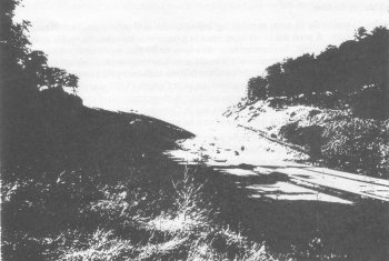
M40 at Stokenchurch. East of Oxford
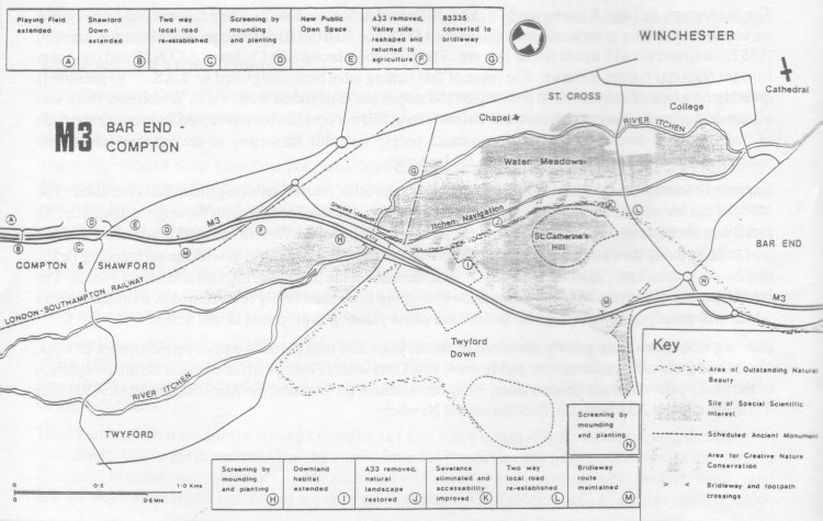
M3 Bar End to Compton
Click to enlarge
Improved contouring of the land adjoining motorways and other roads is reducing their visual intrusion. The M40, as can be seen from the photograph, has the ground re-moulded to link with the original landform. In fact it was very interesting to discover how the present land formation West of the cutting was created. This was done by using the excavated material, which was then contoured to blend in with the surrounding fields, and is now in farm use. No unnatural line is now discernible in the fields, and the traffic is hardly visible. The land in the area where the M3 crosses the railway is going to be extensively recontoured in a similar manner which will greatly lessen the impact. In addition dense planting is proposed in this area.
Planting techniques have greatly advanced in recent years and lead to much earlier establishment of trees, shrubs and grass after construction, and in some cases this work is being carried out well before completion of the roadworks. This can be seen along many recent roads, for instance, the Alresford By-Pass, A303 near Thruxton and the A34 between Winchester and Newbury.
The Tunnel
The idea that a tunnel will hide and get rid of all the evils connected with motor vehicles does not stand up to more detailed investigation in this instance. One needs to look at other items than just the underground part of the road. At each end are twin very large portals (each 19m wide) as gaping holes, the tops and sides retained by concrete, an alien material in the countryside. (Continental tunnels are invariably in rock which is self supporting and only accommodate 2 lane roads). Lights are needed along the stretches of road leaving and entering the tunnel as it is considered dAingerous to go from a lit tunnel into an unlit road. Lighting standards are hideous by day, and even worse by night, introducing a town feature into the countryside, and the lights can be seen from miles away.
As slip roads to get on and off the Motorway and roads from Twyford and More stead to and from the City cannot be accommodated in, or just outside, the tunnel, there have to be bridges over the Motorway, creating a hotch potch of portals, bridges, both with lights, road signs and other paraphanalia linked to our roads and most intrusive into the landscape. The AIM at Hatfield is an example of this conglomeration, fortunately not in an area of attractive countryside.
In many instances lighting of roads is a desecration of our countryside and often ruins an otherwise well landscaped route. The unlit, uncluttered M40 Stokenchurch cutting shows my point.
There would be a need to dispose of the surplus excavated material from the tunnel scheme amounting to 1.6 million cubic metres (over 5 times the quantity for the cutting). This would cover 47 hectares at a depth of 3 metres - where would this go?
Should 4 lanes be necessary the cutting, without further widening, could accommodate this, unlike the tunnel.
Conclusion
Natural chalk in the cutting is far preferable in this Hampshire scenery than the damaging accessories that go with the other routes. After all, the white cliffs of Dover are considered a scenic landmark.
Taking all points into consideration the price of preserving Twyford Down is too high to pay against what would be inflicted elsewhere in environmental terms, quite apart from the £92 million extra cost (at 1987 prices) for the construction of the tunnel element (excluding under the railway) and nearly £1 million for yearly maintenance.
After the findings of two independent Inspectors, and such a vast expense of the inquiries (about £5 million) plus the years of delay occasioned by the re-opening in 1987 so that the Countryside Commission and English Heritage could give evidence, as they failed to appear in 1985, it is now time to accept that everyone who wanted to voice their opinion has had a good opportunity to do so, and the work should start.